Our history
The human history of Mont St. Hilaire is fascinating. The fate of the mountain has been closely connected to the lives of the men and women who have shaped this land. A bit of luck was involved in preserving the Mont St. Hilaire ecosystems. The visionary Brigadier Hamilton Gault was in large part responsible for that. This man’s vision has now been taken up by McGill University.
History of Mont Saint-Hilaire
Before colonization
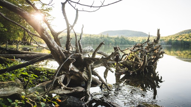
This region originally was home to Indigenous who settled in the St. Lawrence Valley nearly 8,000 years ago. When Jacques Cartier arrived in 1534, he found two tribes in the region: the Algonquins and the Iroquois. The Iroquois were primarily south of the St. Lawrence River. The Algonquins had once occupied that land, but were chased out by the Iroquois. The Algonquins gave the name “Wigwomadensis” to what we now call Mont Saint-Hilaire because its shape resembled that of their dwellings. It is not known if the Indigenous ever had a significant presence on the mountain since no artifacts have ever been discovered.
The arrival of Europeans
Samuel de Champlain explored the region in 1603 and 1609. The European settlement of the region, however, only really began in 1694. Jean-Baptiste Hertel de Rouville had been granted a seigneury that surrounded the mountain as a reward for his military exploits. This reward coincided with the defeat of the Iroquois at the hands of the Carignan-Salière Regiment.
Development of the region under the seigneury system
The development of the region proceeded slowly throughout the 18th century. The first farm was established only in 1731. What is now the municipality of Mont-Saint-Hilaire was the location of three villages at that time. The first was situated near the river and was the first to develop. The second, located on the mountain near the outflow of Lake Hertel, was founded in 1745. The rail station village was developed last with the arrival of the railroad. In 1746 there were only 30 inhabitants in the entire seigneury. In 1751, clearing began on the lower flanks of the mountain and by 1768, a road along the flank of the mountain was established with orchards being planted on the south-facing slopes. This initial phase of European colonization of the region ended with the establishment of parish churches at Saint-Jean-Baptiste (1796) and Mont-Saint-Hilaire on the shore of the Richelieu River (1798).
The mountain village community owed its development to the stream and the energy that it provided. A mill was put into operation in 1750. You can still see the remnants of several mills including the Maison Guérin, located near the entrance of the Reserve, an old seigneurial mill first constructed in 1775 and reconstructed in 1848 after being destroyed by fire in 1840.
A dam was constructed at the Lake Hertel outflow to regulate the water flow. In the 19th century, nine mills, a distillery, three tanneries, two forges and a foundry were powered by that energy. In 1850, about 1,500 people in 260 families lived and worked near the stream, clearly more than the number living in the parish village of Mont-Saint-Hilaire near the river.
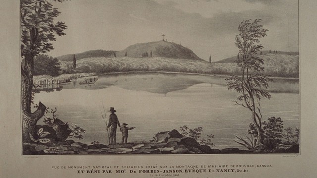
In 1841, a large cross with a chapel at its base was erected on the Pain de Sucre summit. It was 30 metres tall and 9 metres wide, and people could climb up inside it. A winding trail with the stations of the cross led to the summit. Five years later the cross came down in a violent storm. The chapel was completed destroyed by fire in 1876.
The Campbell family
In 1844 the seigneury became the property of the Campbell family. Thomas Campbell built the Lake Hertel dam, rebuilt the mill, promoted the hydraulic industry and constructed the region’s first school. In 1851, he built the Café Campbell on the west shore of Lake Hertel and advertised railroad excursions from Montreal to this mountain retreat. The café was destroyed by fire in 1861.
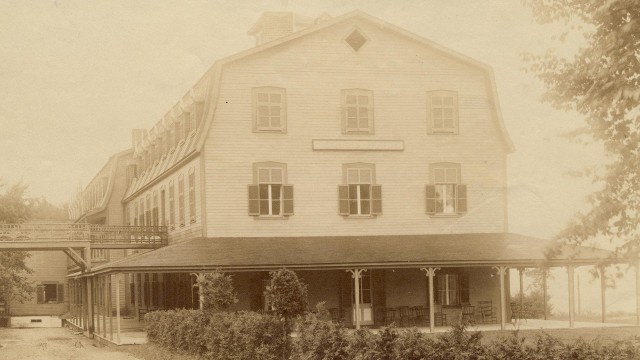
His sons undertook construction of the Hôtel Iroquois and completed it in 1874. It prospered until it was destroyed by fire in 1895. It is believed that it was located near the current Manager’s House.
Development of the mountain village and its surroundings ended at that time. Tourists would only come to the mountain for the day preferring instead to visit the Eastern Townships. In addition, steam power arrived and replaced the mills. The parish became the centre of activity. People left the mountain and it returned to a state of peace and tranquillity.
Texts and archival photos: Société d'histoire de Beloeil - Mont-Saint-Hilaire
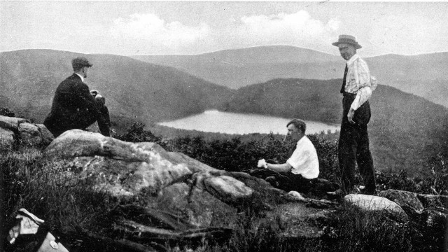
Andrew Hamilton Gault
In 1913, the Campbell family sold 890 hectares of its property to a wealthy young man, Andrew Hamilton Gault. By 1920, the 522 inhabitants of Saint-Hilaire had electricity, and there were 802 other inhabitants in the neighbouring countryside. By 1941, an aqueduct from Lake Hertel was supplying water to the 5,000 homes in Saint-Hilaire and Beloeil.
Gault spent many summers on his property. He loved nature and his mountain and he was required to defend it many times to keep it all intact, fighting off uranium and diamond mining prospectors as well as expropriation threats to his lands for sandpit operations. Gault would remain vigilant and firm. In 1940, he sold his Lake Hertel water rights to the municipality of Beloeil.
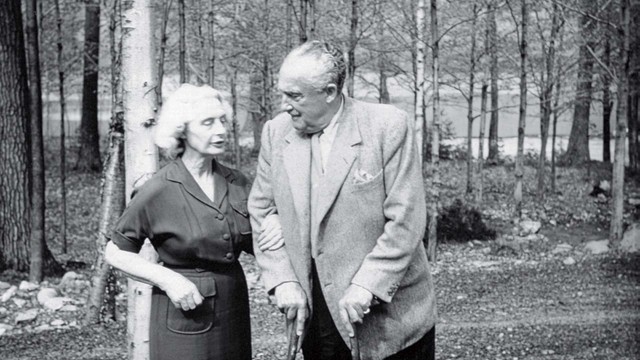
In 1957, Gault constructed a vast manor house on the shores of Lake Hertel where he lived for a few months before his death. He left his entire property to McGill University knowing that a well-established institution of higher learning would be able to protect the mountain for future generations.
The Gault Nature Reserve thus passed to McGill University in 1958 through a bequest from Brigadier Andrew Hamilton Gault that specified:
"...that its beauties and amenities may be preserved for all time to come, not only to the immediate interests of the university itself, but through its corridors of learning, as a great heritage for the benefit and enjoyment of the youth of Canada."
Gault Nature Reserve's history
From 1958 to 1968, following the recommendations in the Hare Report, the Gault Nature Reserve was used for teaching and research by various departments of the University and also continued to be used by local residents and the general public.
In 1960, the mountain was designated a migratory bird sanctuary.
In 1970, McGill University commissioned the Audubon Society to conduct a detailed study of the mountain. The principal recommendations were to separate the Reserve into three separate management sectors to continue protecting the mountain from abuses associated with inappropriate use by people.
In 1972, Alice Johannsen, the director of what was then called the Gault Estate, founded the Mont Saint-Hilaire Nature Conservation Centre, a non-profit organization devoted to conservation and education.
In 1977, the Gault Estate board of directors developed a master plan emphasizing the property’s dual nature. The Estate was to be used for university teaching and research and to provide access for the general public.
In 1978, the Gault Estate was designated the first Canadian Biosphere Reserve as part of UNESCO's Man and the Biosphere Program.
In 1995, management of the Gault Estate was separated from the Nature Centre.
In 2000, the Gault Estate was officially renamed the Gault Nature Reserve to better reflect the conservation mission of this McGill University property.
In 2004, the Gault Nature Reserve is officially designated a private land reserve by the Ministère du Développement durable, de l’Environnement et des Parcs du Québec according to the law on conservation of natural patrimony.
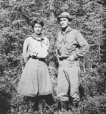
Brigadier Gault in the forest.